
Everywhere I looked I saw the wall, in all directions. Here we got out of the car and had to walk. I wanted to get to the Jerusaelm-Hebron Road and examine the area around Rachel's Tomb and we couldn't drive since the road was blocked, chopped and split in several places. (Emily Jacir)

This is Clair Anastas' house. It is surrounded by all three sides by the wall. (Emily Jacir)

Back on the Jerusalem-Hebron Road, businesses have shut down as the wall has completely isolated them. There is no road here any longer -- it is more like an alleyway -- the rest of the formerly wide road is now on the other side of the wall, part of Rachel's Tomb. (Emily Jacir)
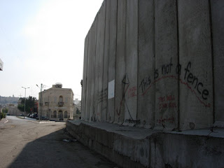
Facing the direction of Hebron, the Rachel's Tomb complex on the right behind the wall. The road to the left of the house leads to Manger Square. Rachel's Tomb and the surrounding area which they have enclosed behind the wall is all Bethlehem's land. In September 2006 the Israeli government officially annexed it as part of Jerusalem. (Emily Jacir)

This is the view from the north side of Rachel's Tomb, and the Lama Brothers souvenir shop cut off from the rest of Bethlehem. (Emily Jacir)
# posted by umkahlil @ 10:15 PM


